- TSX.V: ASQ $0.09
- Frankfurt: 47A.F $0.06
Astorius Resources Ltd Drills 9.14 meters at 3.69 grams per ton gold during first ever drilling at Rainbow Canyon, Nevada
Vancouver BC, July 6, 2017, Astorius Resources Ltd. (TSX VENTURE: ASQ) ("Astorius" or the "Company") is pleased to announce that it has received encouraging results from an initial six hole RC program at the north-eastern end of its Rainbow Canyon gold property in Nevada – the first known drilling ever to have taken place on the property. Highlights of the drilling results are:
- Borehole RCR-03 intersected 1.52 meters grading 19.65g/t gold from 100.58m to 102.11m, within an intersection of 9.14m at 3.69g/t Au;
- Borehole RCR-03 is on the margin of a magnetic low, previously interpreted to be an alteration zone, now a significant target for further drilling;
- Gold mineralisation appears to be structurally controlled, and is present within a number of rock units on the property, apparently in a number of sub-parallel corridors running NE/SW;
- This is the first known drilling on the property, which has tested only 400 meters of 3,000 meters of strike over which surface mineralisation has been observed.
Rainbow Canyon is a 417 hectare low-sulfidation gold prospect located in the northern Walker Lane structural and metallogenic domain. Andesites, basalts and rhyolites of the Miocene Alta and Old Gregory Formation underlie most of the property. Forty kilometers to the southwest of Rainbow Canyon the Alta Formation is also host to the world-renowned Comstock Mine, a low sulfidation lode deposit which produced 8.4 million ounces gold. Eight kilometers to the north-west of Rainbow Canyon the Olinghouse gold deposit has reported a non-43-101-compliant resource of slightly over one million ounces of gold (Wilson et al, 1999).
A total of six holes were drilled for a total of 2,780 feet (847m). Five holes targeted a NE trending corridor of gold-mineralised quartz veins dipping to the SE, and one hole targeted a second smaller corridor SE of the main mineralised corridor. Table 1 below lists location and drilling results for each borehole, and Figure 1 below shows the collar locations of holes drilled. Borehole logging results and downhole profiles for a number of elements in hole RCR-03 are shown in Figure 3.
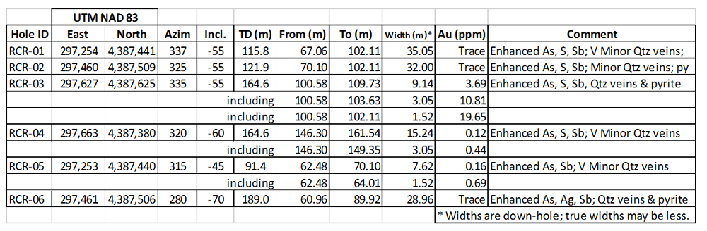
Table 1: Drill hole details and summary drilling results.
The RCR-03 profiles in Figure 2 illustrate the correlation of gold with enhanced arsenic, sulphur, silver and antimony, as well as with pyrite and quartz vein material observed in the drill chips. Mercury is also anomalous in the mineralised zone. These are expected associations within low sulphidation gold mineralisation, and were observed in the other holes drilled within the intervals indicated in Table 1.

Figure 1: Drill collar locations on the Rainbow Canyon property.
RCR-03 is an isolated hole on the south-western margin of a 400m by 200m magnetic low, which, prior to drilling, was interpreted to be the result of alteration (Figure 3). The high-grade intersection it has yielded now calls for additional drilling both below and to the north and north-east of RCR-03.
All samples were prepared from drill cuttings processed through a rotary splitter on site. Split drill cutting samples were sent to American Assay Laboratories in Reno, Nevada, for total gold and multi-element analyses. Standards, blanks, and duplicates were included at regular intervals in each sample batch as part of Astorius’ quality control program.
These results enhance our understanding of the basic geometry of the gold-mineralizing system at Rainbow Canyon, and give us confidence that the system extends to depth.
Astorius is now planning a follow-up program comprising the following:
- Step-out drilling around borehole RCR-03, in particular to test the interpreted low magnetisation alteration zone;
- Extending surface structural and lithology mapping from the north-east of the property (partially mapped in detail) to the surface mineralisation in the south west (never mapped in detail);
- Conducting a concurrent soil geochemical sampling program over the south-western two thirds of the property to detect mineralisation covered by soil – these latter two programs focused on identifying drill targets in higher-tenor mineralised dilation zones.
The technical information within this news release has been reviewed and approved by Clinton Smyth, P. Geo, and Astorius’ Qualified Person as defined in NI 43-101. The drilling program reported in this news release was carried out under the direction of Mr. Smyth.
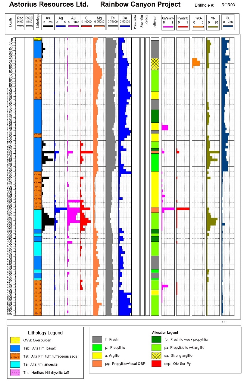
Figure 2: Downhole profiles and logging results for borehole RCR-03.
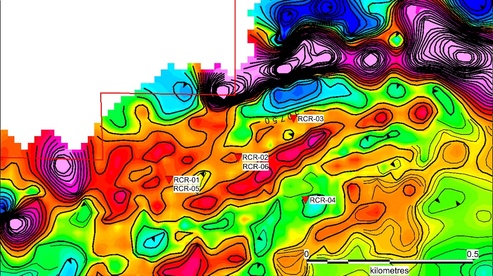
Figure 3: Borehole locations with respect to a magnetic low north of RCR-03.
More great reads
- UK Online Casinos Not On Gamstop
- Migliori Casino Online
- Migliori Bonus Benvenuto Casino
- Casino En Ligne
- Casinos Not On Gamstop
- Casino Not On Gamstop
- Siti Casino Criptovalute
- Non Gamstop Casinos UK
- Non Gamstop Casino UK
- Casino En Ligne France
- Non Gamstop Casinos
- Non Gamstop Casinos
- Non Gamstop Casino UK
- Non Gamstop Casinos
- Best Online Casinos
- Slots Not On Gamstop
- Non Gamstop Casino Sites UK
- Casino En Ligne Fiable
- Non Gamstop Casinos
- Online Casino Zonder Cruks
- Non Gamstop Casino UK
- Casino Sites UK Not On Gamstop
- Casino Online Non Aams
- Casinos Not On Gamstop
- I Migliori Casino Online
- Crypto Casinos
- Casino En Ligne Belgique Bonus
- Bookmaker Non Aams
- Poker Online I Migliori Siti
- Casino En Ligne
- Plinko Avis
- ライブ カジノ
- Meilleur Casino En Ligne
- Casino En Ligne France Légal
- Nouveau Casino En Ligne France
- Migliori Siti Scommesse Non Aams
- Meilleur Casino En Ligne
- Meilleur Casino En Ligne
- Casino En Ligne France Gratuit
- Meilleurs Casino En Ligne
- Migliori Crypto Casino
- Casino Online Non AAMS
- Casino En Ligne
- Meilleur Casino En Ligne
- Siti Poker Non Aams
- Meilleurs Casino Crypto
- Casino Online Non AAMS
- Casino En Ligne
